

|
OUTDOOR
ICT PROJECT E SENIORS
ACTIVITIES during the period 2011-2013 |
Since the decisions taken at the first meeting E SENIORS had organized
for this project various activities :
|
OUTDOOR
ICT PROJECT E SENIORS
ACTIVITIES during the period 2011-2013 |
Since the decisions taken at the first meeting E SENIORS had organized
for this project various activities :
Summary............................................................................................................................................... 1
Indoor activities :.................................................................................................................................. 3
Outdoor activities :............................................................................................................................... 4
Dissemination ...................................................................................................................................... 5
Technical research for suitable software :
Institute E seniors
has first asked their technicians to study the software
"OPENSTREETMAP" (www.openstreetmap.fr or www.openstreetmap.org) and also
two editing tools « Potlatch2 and JOSM », in order to be
able to prepare courses supports for their teachers.
The technicians took as
example the creation of a pedestrian circuit in an area of Paris called
"The circuit of churches of the
Marais." They got into the role of a senior living in the Paris area.
But here are the
technical difficulties encountered :
-impossibility to create new routes on
the existing ones and especially to keep them; there is a moderator for the
site and he removes post of the daily
updates , unless he can agree that it is of general interest and therefore
worth keeping
-the only additions accepted by the
moderator are paths created in the
countryside, which is not an interesting case for us,
-it is therefore only possible to keep their creations on
paper , which greatly reduces the interest,
-difficulty of understanding by all
students because the site is in English and all their seniors are not
bilingual,
-the existing icons have a label
different from that usually used in France : this means some more difficulty of understanding for
their seniors,
-to create new icons you need to
download another software and work on two software at once: another difficulty for
their seniors.
After their next steps before making or
offering course materials for their teachers are :
1. Go thoroughly into the site “GOOGLE
EARTH” and in particular explore the possibility of keeping the work.
2.
Go thoroughly into the editor "JOSM" as to make it compatible with their goals.
3. Finally discovery new products that could be used for the
project and that they have to study as well: http://showmystreet.com/ and TripGeo (Google procuct) http://tripgeo.com/Home.aspx
And also http://www.vianavigo.com/
Before the
beginning of the courses/workshops, the teachers made tests and discovered that these programs were
not “user-friendly” so we decided to use "google
maps" for the workshops.
- 5 series of ICT courses with the
subject « geolocalisation, google
maps, geocaching ».
We made this series of
courses in the different
places all over Paris where we usually offer courses about digital
technologies :
Pole Actiseniors of the Town Hall - 4th
quarter of Paris
Centre d’animation MJC Mercoeur – Paris 11ème
Centre Social CAF paris 12ème
Centre d’animation Daviel - 13th
quarter
Maison des associations eue
de la Saïda – Paris 15 ème
Centre Eseniors
– rue du Cambodge – Paris 20 ème
Periods : Winter 2012, Spring 2012,
Autumn 2012, Winter 2013 and Spring 2013.
Here is a link to the French tutorial about Google Maps
:
https://docs.google.com/file/d/0B9zbxeqeaogkbWZLRllCU05aVjg/edit
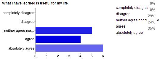
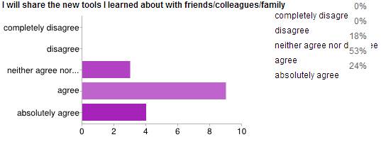
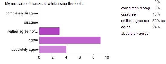
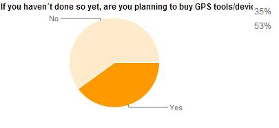
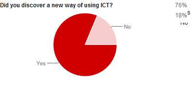
After the courses, we asked the
learners to complete a questionnaire.
The main questions were :
- What I have learned is useful for my life
-The training methodology was adequate to my knowledge and
needs
-I will share the new tools I learned about with
friends/colleagues/family .
-My motivation increased while using the
tools
-If you
haven´t done so yet, are you planning to buy GPS tools/devices
?
-Did
you discover a new way of using ICT?
The results have helped
us to adapt our courses.
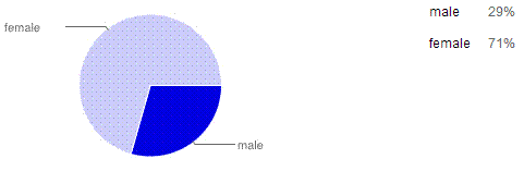
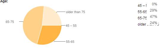
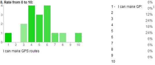
Here you can see the
statistical of the main resultats of the
questionnaire:
![]()
In each case, we used the local spots of interest as support for the
course and could create maps for local trips.
- many private lessons at home for
learners with more difficulties and to
follow some group courses …
- use on the outside of the maps produced
during the courses:
Paris is a big town and it is
very difficult to make nature walks but we have made cultural walks, in
particular routes in the old quarter of Paris «Le Marais».
Some students have made cards to make trekking in the suburbs of Paris :
-
in the forest of
Fontainebleau where there is a
lot of marked hiking trails
-
we intend to organize trips in Giverny (circuit of impressionism and house of painter
Monet) in the beginning of summer 2013 and will be using maps on smart phones
-testing geolocalisation
During holidays we
have tried different
experiences with a few learners :
«treasure
hunts» in Limousin based on geocaching.
People need smart
phones or GPS or walking sticks with MP3 to make
the game.
At the end, we find a cache
where is the treasure!!!
The targets are multiple : family, children, hikers, music lovers and the themes are various : sightseeing, nature, heritage discovery, old crafts,
But before starting this geocaching game, the travel time, the difficulty, and the distance to be
covered are noted on a paper: so the
people can test their physical capabilities and decide if they are able to made
or not this game.
For example:
1) Geocaching about
diamonds in a little town where this
stone was
extraction
2) Circuit of the
"Masons in the Creuse area"
: geocaching in the typical villages build
with the expertise of these professionals masons and study of their
construction methods
3) Rando Geocaching about tales and legends of «Plateau de Millevaches»
- a circuit
of about 10 km (foot or VTT)
4)Musical geocaching steps
on the theme of water around lakes with
MP3 …..
http://www.felletin-tourisme.fr/activites-loisirs/geocaching/
All this activities have been achieved thanks
to the publicity of our project made in different forums and by distribution
and displayed in many libraries of our specific flyer as well as repeated
announcements in our regular newsletter.